
CHARLOTTE, N.C. — A storm system that is expected to become Hurricane Helene and currently identified as Potential Tropical Cyclone Nine is forecast to form in the Gulf of Mexico.
The current cluster of thunderstorms associated with this future storm is currently identified by meteorologists as PTC9. Rapid intensification is expected to quickly grow the storm into Tropical Depression No. 9, then Tropical Storm Helene and eventually Hurricane Helene.
RAISE YOUR WEATHER IQ: What is a 'potential tropical cyclone?'
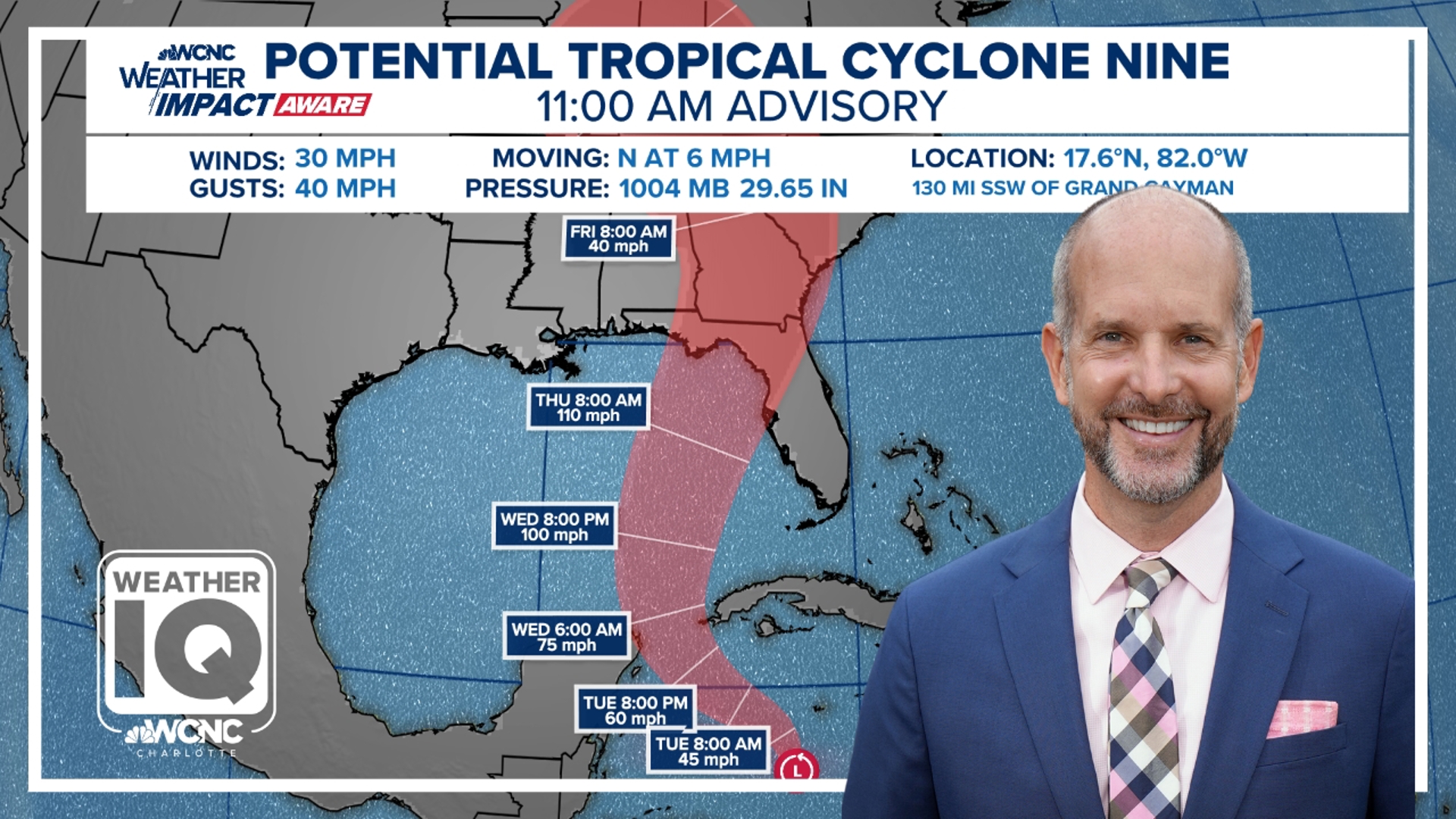
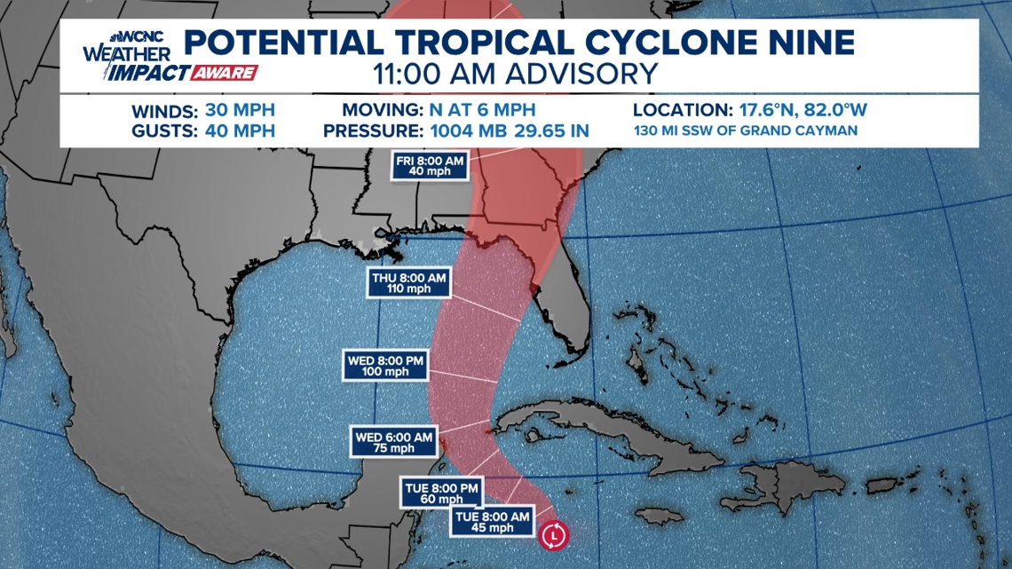
On Monday, the hurricane hunters flew a plan through the thunderstorms to take measurements. As of 11 p.m. on Monday, they found the storm had maximum sustained winds of 35 mph and was moving north-northwest at 6 mph. Among other characteristics, the storm needs winds of 39 mph before it can be considered a tropical storm.
The storm is expected to grow as it nears landfall along the Gulf Coast by Friday. Then expected to be Hurricane Helene, the storm is forecast to bring flooding, damaging winds and dangerous storm surge to Florida, Alabama and the Gulf Coast.
As the storm moves further inland, impacts from excessive rain are expected to bring flooding to Georgia, South Carolina, North Carolina and Tennessee.
Just as the National Hurricane Center was issuing its first forecast cone for the storm on Monday morning, WCNC Weather Impact Chief Meteorologist Brad Panovich published a video vlog explaining his expected impacts from the storm.
Rapid intensification
"There's a 35% chance of rapid intensification here in the next couple of days," Panovich said of the storm's expected growth ahead of landfall. "As far as intensity, it definitely looks like a major hurricane."
A "major hurricane" is defined by the National Hurricane Center as any storm Category 3 or higher. That means the storm would have at least sustained winds of 111 mph, according to the Saffir-Simpson hurricane wind scale.
RAISE YOUR WEATHER IQ: Inside the powerful winds of a hurricane
"Regardless of strength, the impacts are going to be pretty devastating somewhere on the coast," Panovich said in the vlog, which was posted to the WCNC Charlotte Weather IQ YouTube channel on Monday morning.

"So, I would not focus solely on the category. I would focus on the fact that this is going to be a significant storm and you need to pay attention to the system," Panovich said. "Don't look at the specifics we're in the range where you need to focus on the bigger picture."
Florida landfall
For Florida, that big picture is huge storm surge, damaging winds and life-threatening flooding. Where and when that exactly occurs is not immediately known. Better clarity on timing and location are expected as the storm continues to form and moves toward the U.S.
Panovich advises the entirety of Florida's west coast to begin preparations.

Carolina impacts
In the Carolinas, excessive rainfall is expected to bring flash flooding.
"We've got the high pressure off the East Coast. So everything's gonna be funneling moisture into the Southeast," Panovich explained. "So for the Carolinas in particular ... huge flash flooding risk here"

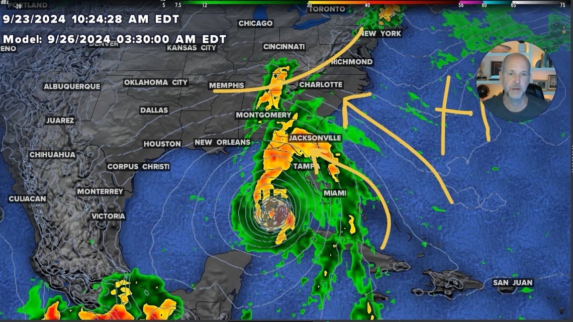
The worst of the flooding could be in the mountains of western North Carolina.
"This is where we're gonna have strong southeast winds interacting with the Blue Ridge Mountains," Panovich said. "You'll see some of these totals coming out of the mountains are approaching 10 inches or above."
Around Charlotte, general rainfall amounts could amount to a couple of inches.
"So this is a significant flash flood risk to the mountains of North Carolina, upstate South Carolina and northeast Georgia," Panovich said. "This is gonna have the potential to have a huge impact on parts of our area in the form of rain."
The WCNC Weather Impact Team is tracking the storm and issuing forecast updates several times a day. Check back for the latest forecast path and expected impacts.