TYLER, Texas — Beryl made landfall as a Category 1 hurricane Monday morning near Matagorda. Before making its way to East Texas, it was downgraded to a Tropical Storm with the potential to produce heavy rainfall and quick, spin-up tornadoes.
Parts of East Texas could see wind gusts close at or near tropical storm-force Monday evening into overnight Tuesday.
Our team will be tracking the storm both on-air and online and want you to know:
- Winds gusting up to 45 mph could knock down trees weakened by past wind events or the heavy rain that comes with the remnants of Beryl.
- Forecast models suggest between 2''-7" of rain will be possible over parts of East Texas.
Follow this live blog for the most up-to-date information on Beryl.
▶Monday, July 8
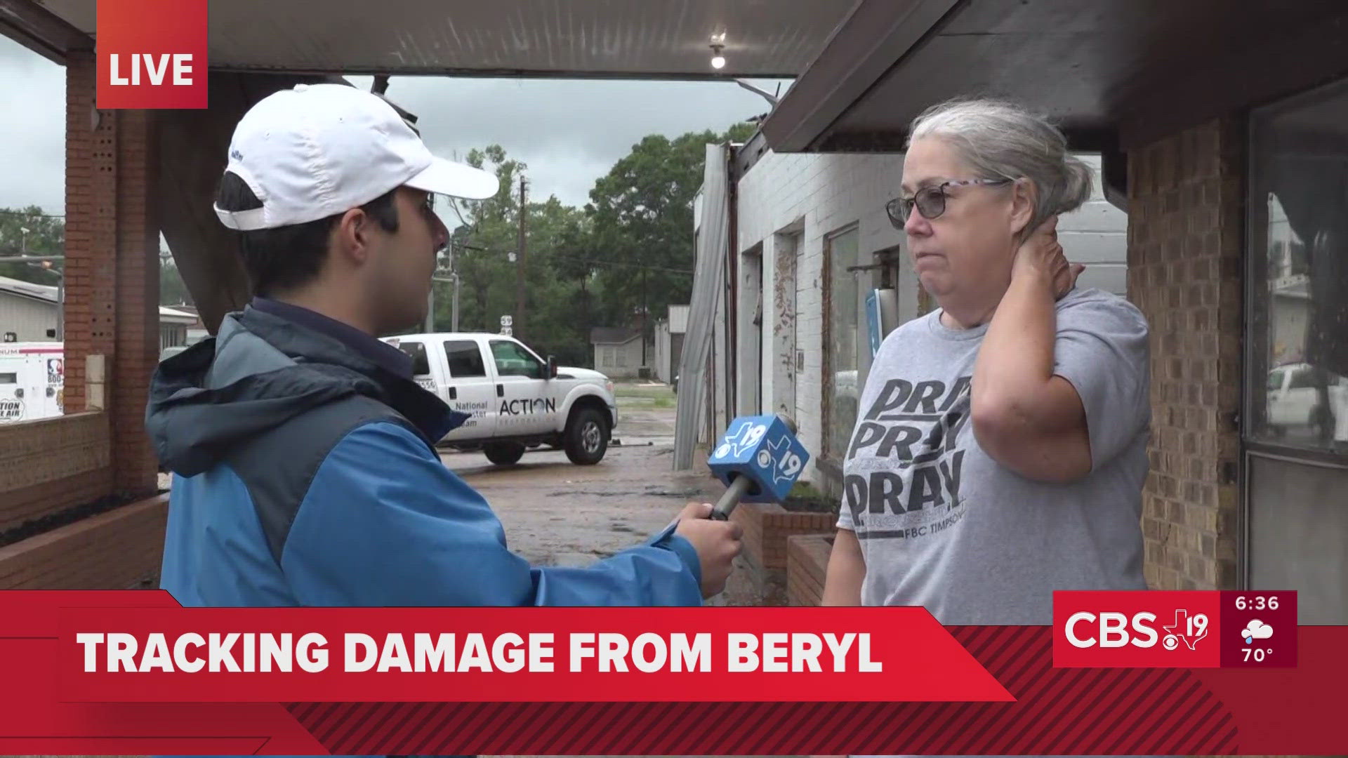
7:25 PM - Timpson Mayor Debra Smith told CBS19 that the storm caused significant damage to buildings across the town, including City Hall, and road closures. Officials are working to recover records from City Hall and responding to storm cleanup needs. She encouraged people in the area to stay at home unless they have to leave.
See an interview with Smith below:


5:27 PM - Beryl is set to move out of East Texas overnight. So, what should you expect? Check out the video below for more.
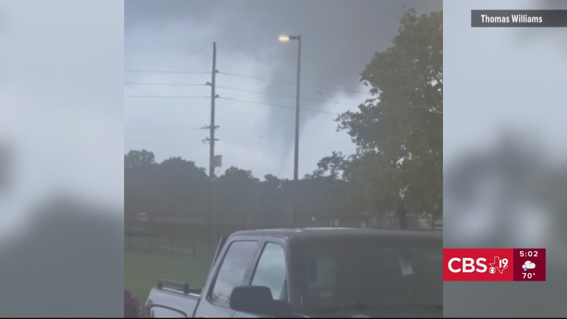
5:20 PM - A small tornado was caught on camera in the Beaumont area of Southeast Texas. Watch the footage in the video below.
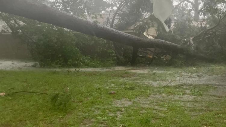
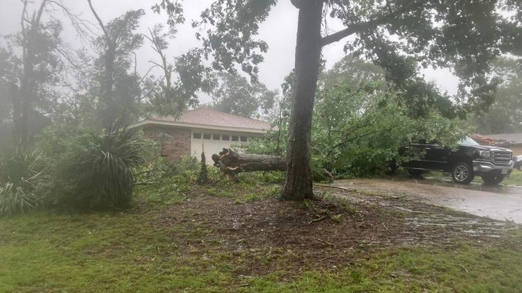
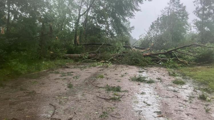
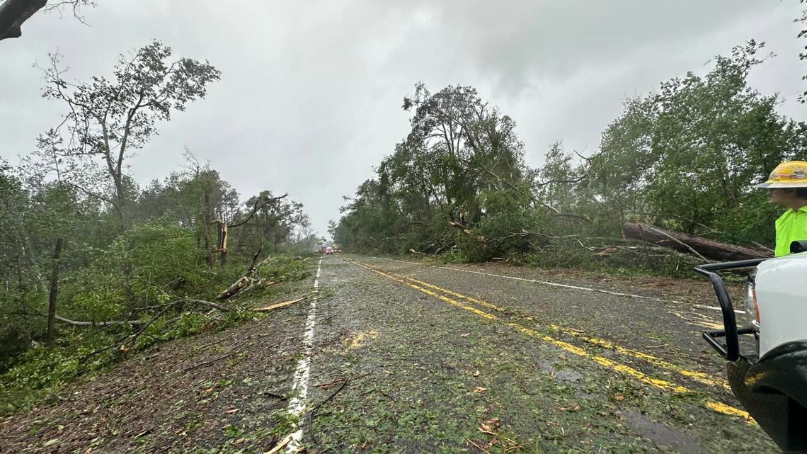
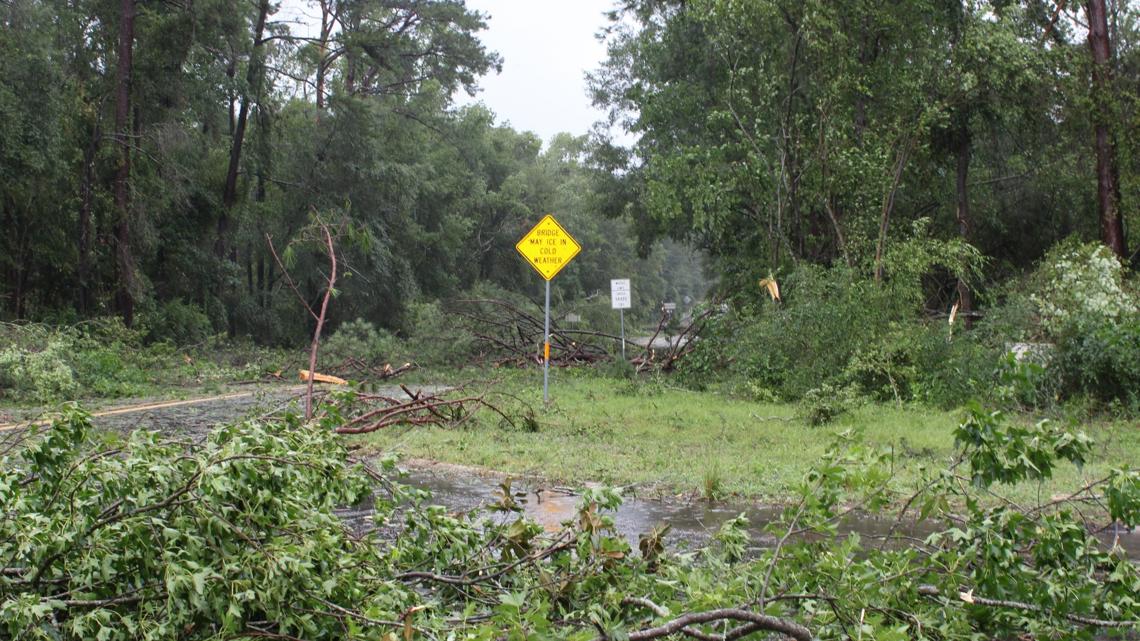
5:15 PM - Widespread damage and flooding is being reported across East Texas. Check out the video below for more.
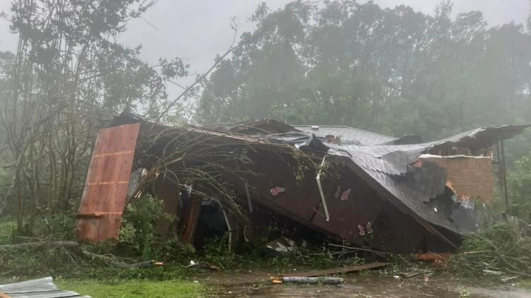
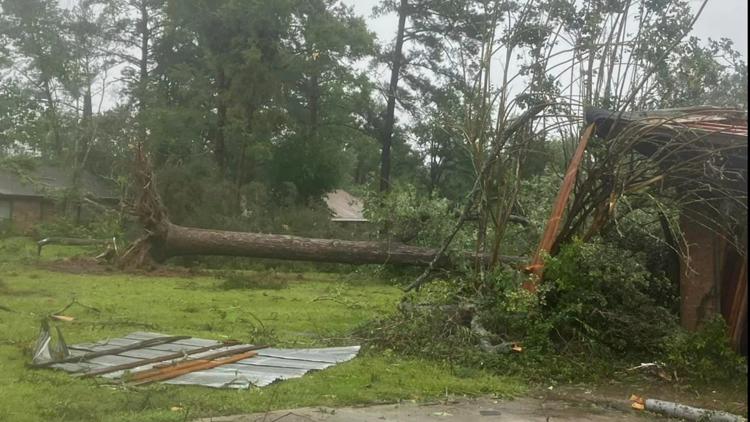
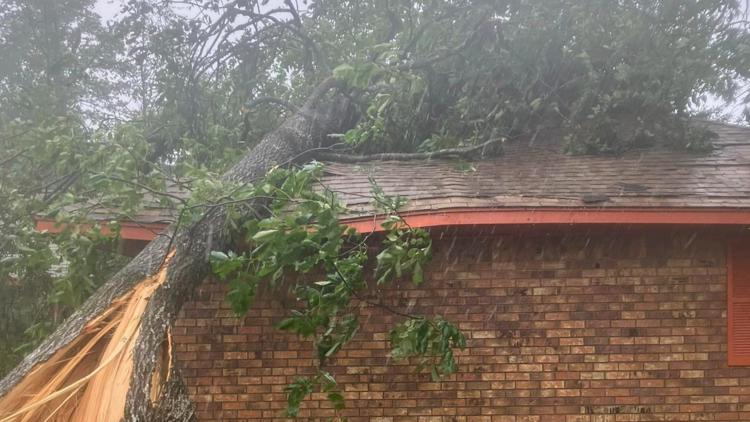
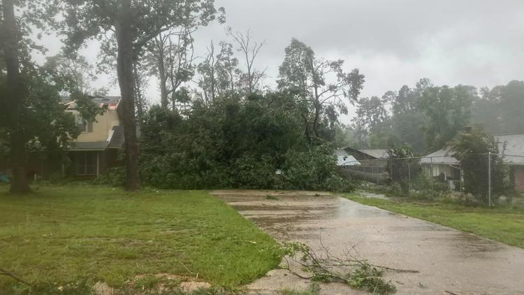
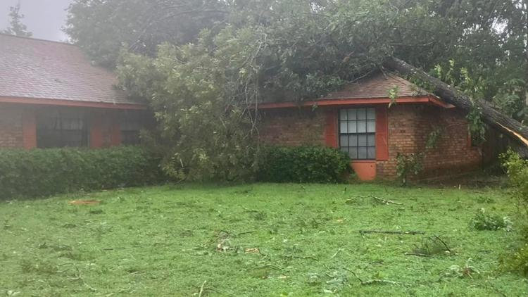
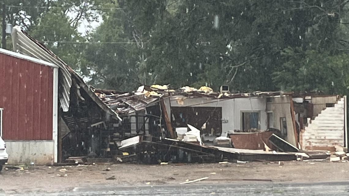
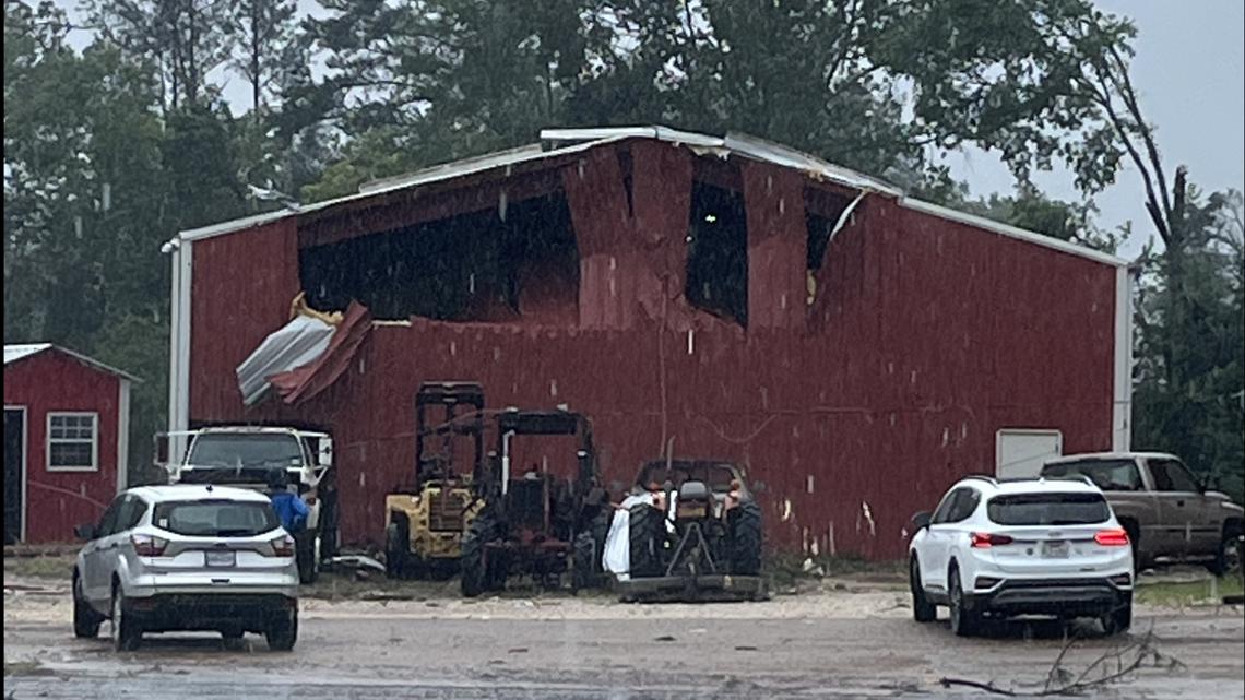
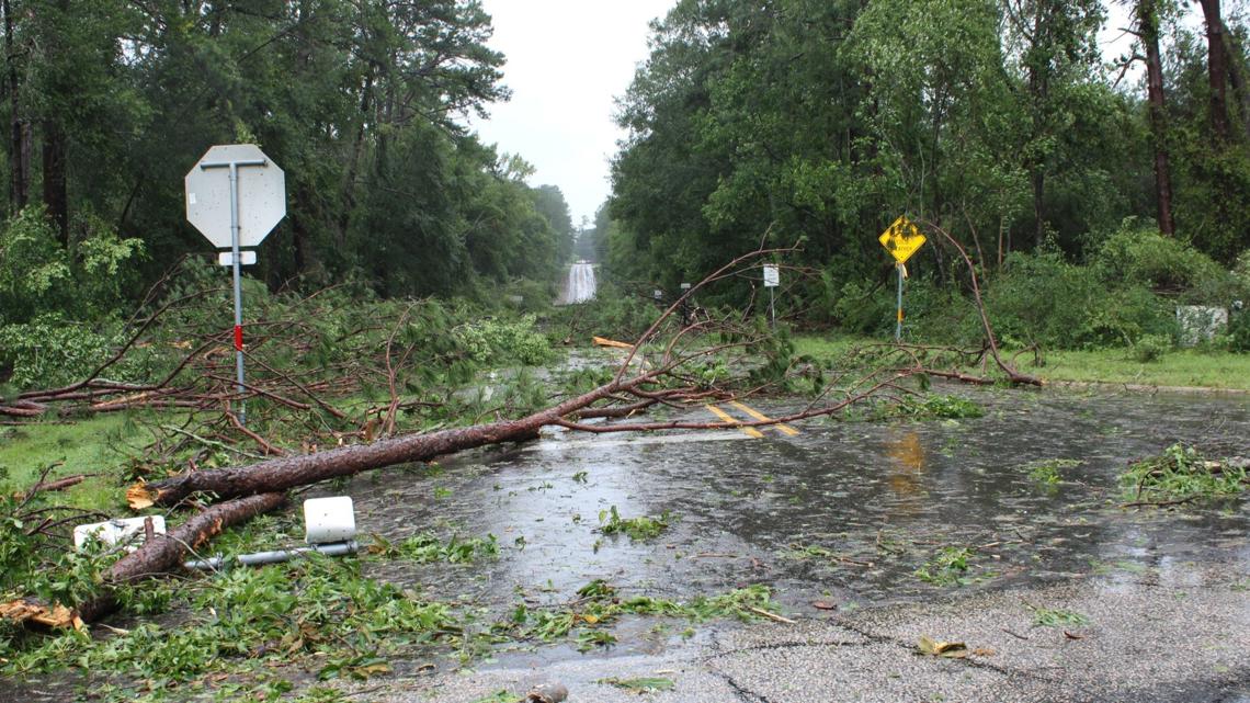
4:45 PM - Beech Grove Volunteer Fire Department in Jasper reported Monday afternoon that there was extensive wind and storm damage in the Shady Acres and Rosewood Subdivisions on the west side of Jasper. Multiple houses have trees on them.
PHOTOS: Multiple trees fall on houses in Jasper-area subdivisions


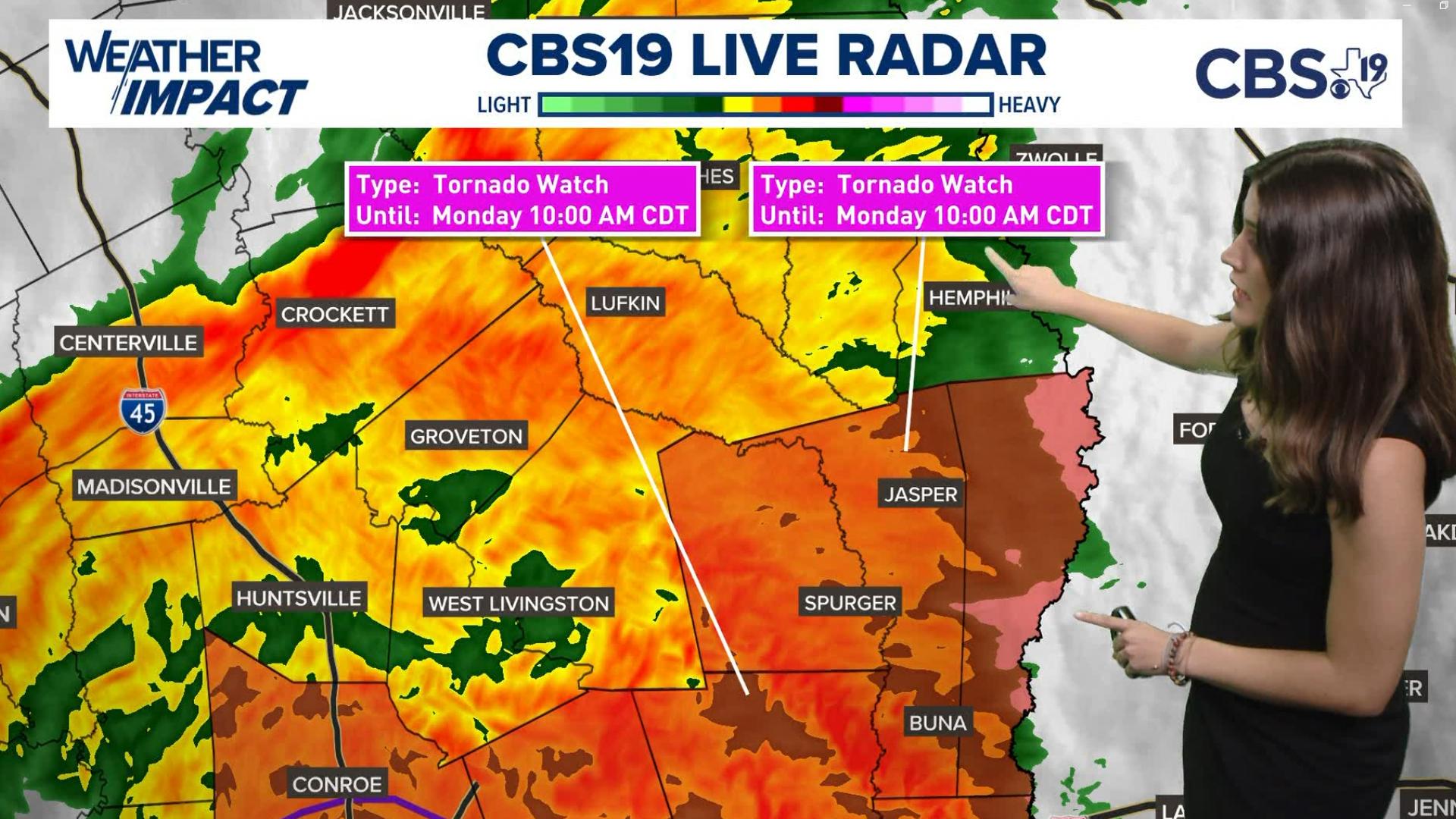
4:23 PM - The NWS has issued a Tornado Warning till 5:15 p.m. for Cass County.
4:12 PM - The NWS has issued a Tornado Warning till 5 p.m. for the following counties:
- Wood
- Upshur
- Gregg
- Smith
- Cass
- Morris
- Titus
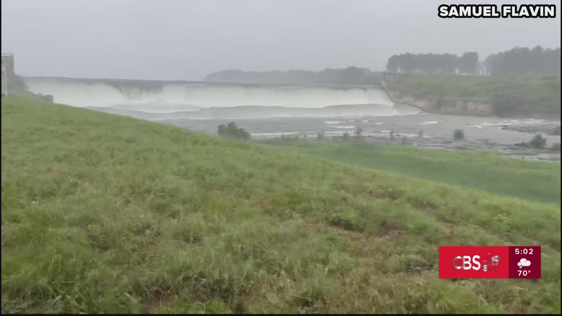
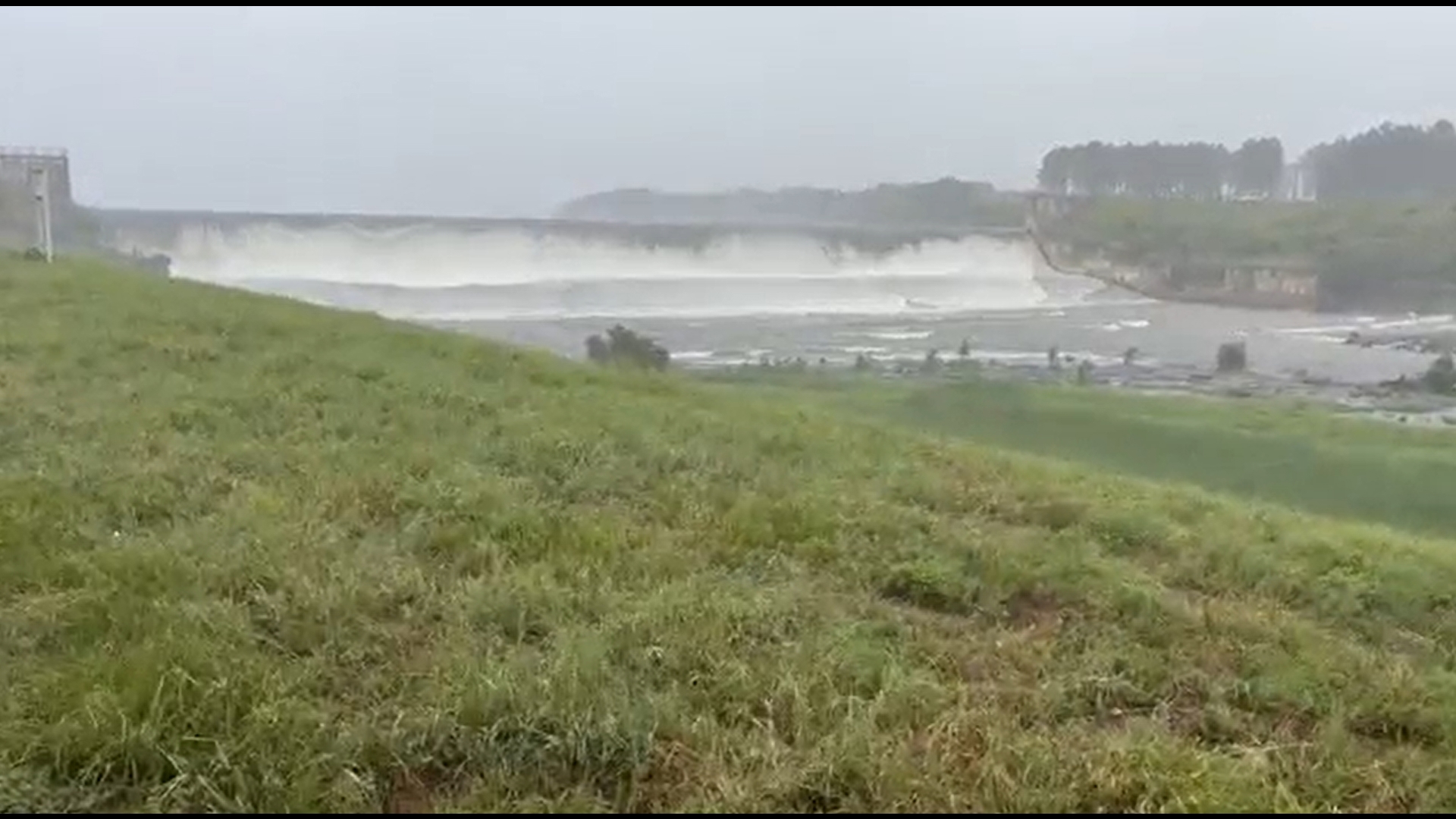
3:45 PM - Video sent in shows the Frankston dam and flooding around that area.
3:40 PM- All city offices in Lufkin are closed due to a widespread power outage. Lufkin is also closing its Beryl call center, but we will continue to take reports of downed trees and power lines by reporting them https://col-it-test.formstack.com/forms/street_department_work_order. The online reporting system is for tree, power line and debris issues inside Lufkin city limits.
3:45 PM - The NWS has issued a Tornado Warning till 4:30 p.m. for the following counties:
- Marion
- Morris
- Cass
3:40 PM - Cherokee County Electric Company has shown damage in the county.


3:30 PM - The NWS has issued a Tornado Warning till 4:15 PM for the following counties:
- Rusk
- Gregg
- Panola
3:10 PM - Gregg County Chief Deputy Craig Harrington reported a possible tornado on the ground heading toward the Judson community. The Gregg County Sheriff's Office is monitoring the situation closely.
The NWS has issued a Tornado Warning till 4 PM for the following counties:
- Sabine
- Shelby
- San Augustine
3 PM - The NWS has issued a Tornado Warning till 3:45 PM for the following counties:
- Harrison
- Upshur
- Gregg
- Camp
- Rusk
- Nacogdoches
- Panola
- Cass
- Marion
2:50 PM - According to the city of Timpson, most roads are closed to the public. People are asked to stay at home unless it’s an emergency.
Timpson Mayor Debra Smith also reported that City Hall has been damaged. The Quick Stop and other buildings in the city have seen damage as well.
"Do not come to Timpson at this time," the city said in a statement.
The Shelby County Sheriff's Office reported the following closures in Timpson:
- FM 1970
- Marcus Street
- Pecan Street
- Fourth Street
- Fifth Street
2:18 PM - The NWS has issued a Tornado Warning till 3 PM for the following counties.
- Harrison
- Rusk
- Gregg
- Panola
2:15 PM - Damage is being reported in Appleby community near Nacogdoches.


2:07 PM - The NWS has issued a Tornado Warning for the following counties until 2:45 p.m.:
- Harrison
- Gregg
- Smith
- Rusk
- Upshur
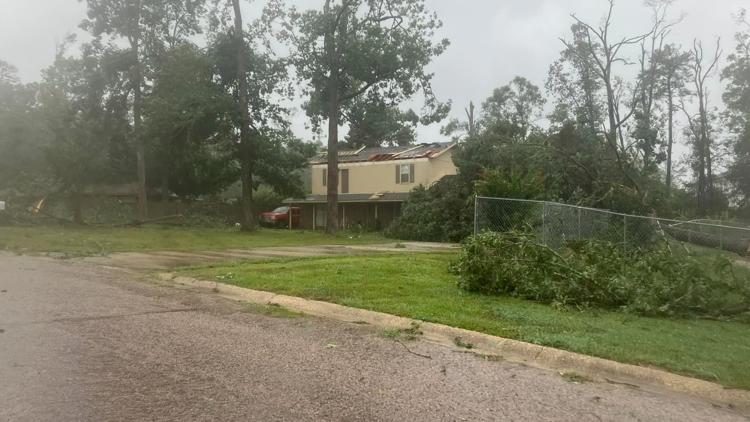
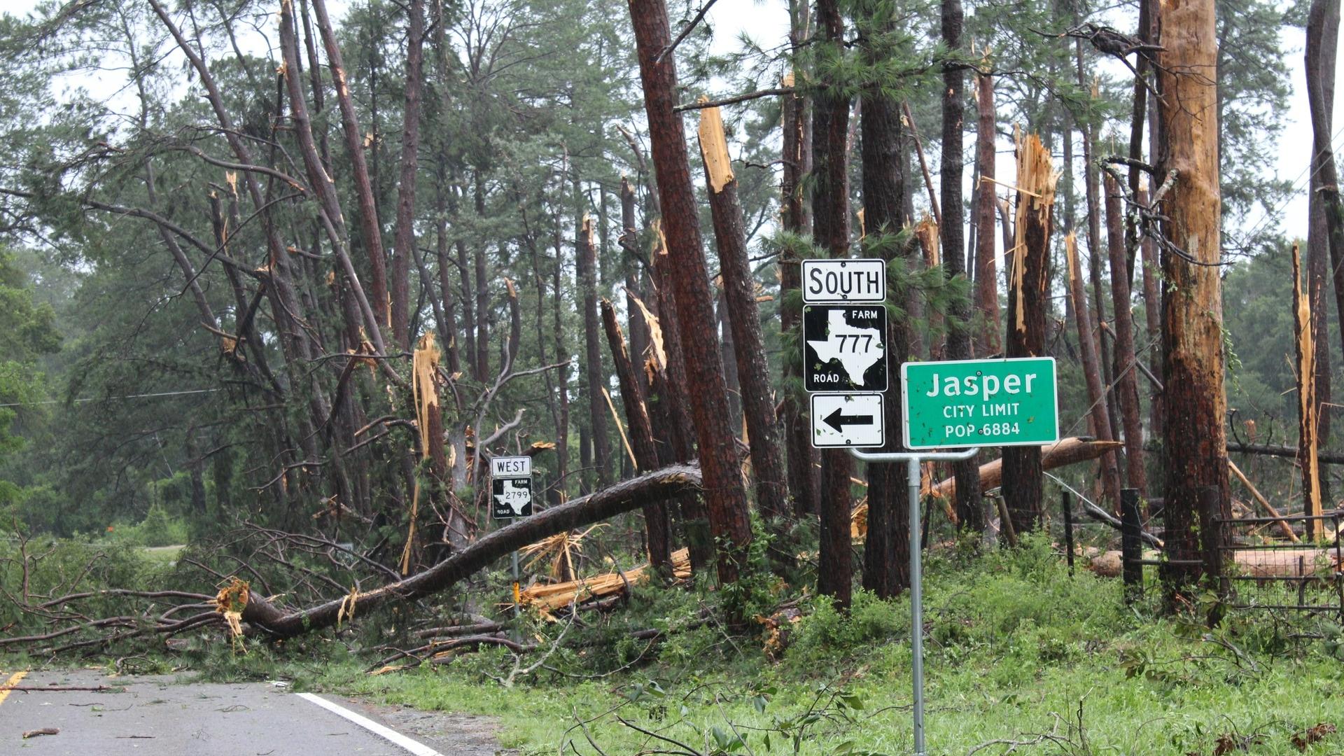
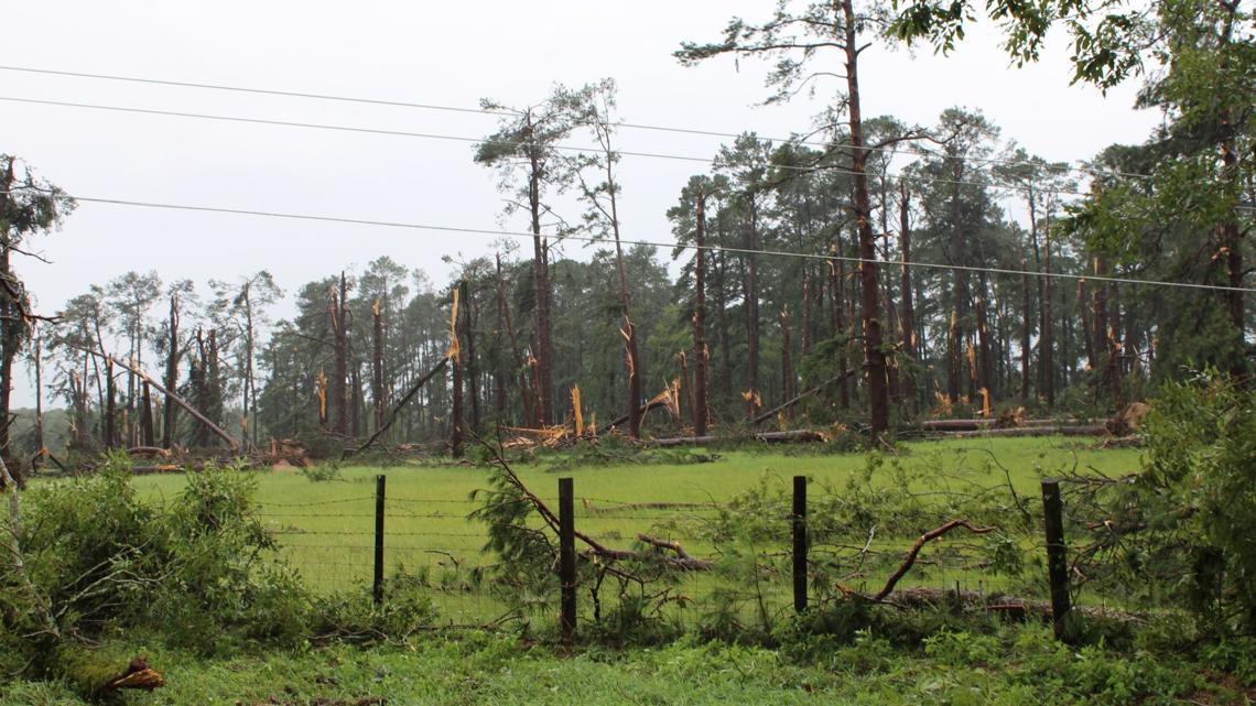
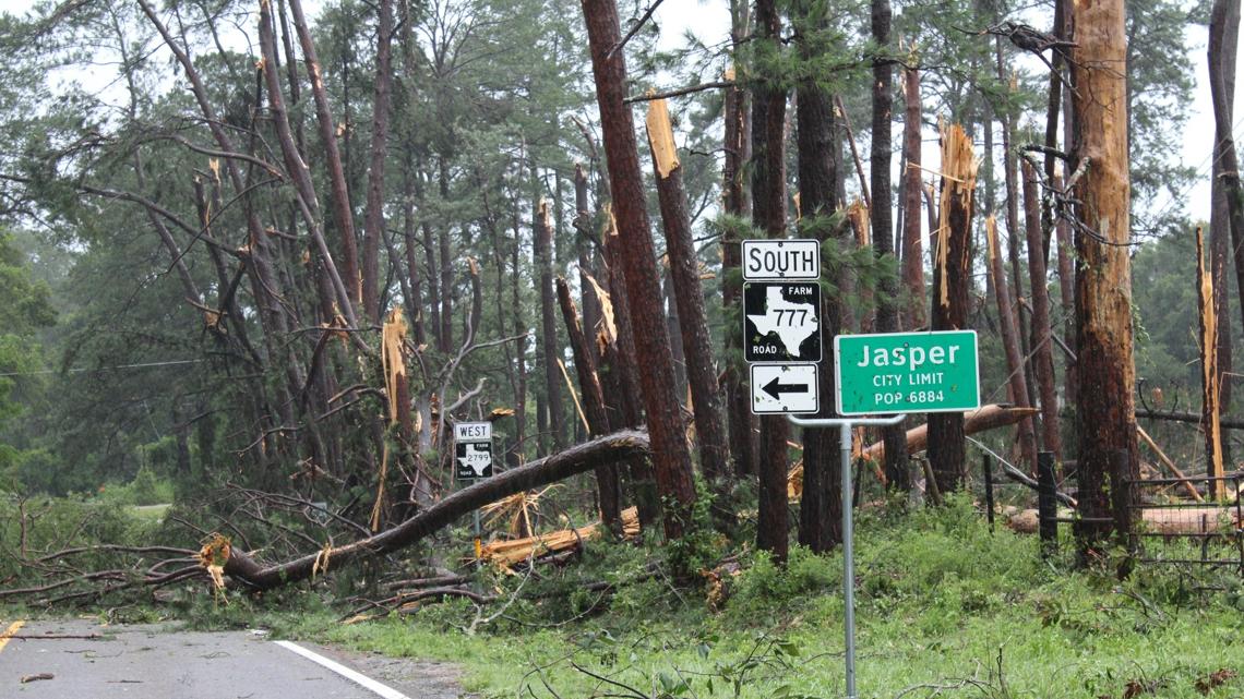
1:47 PM - The City of Jasper is reporting extensive damage from a possible tornado.


1:42 PM - The NWS has issued a Tornado Warning for Harrison and Panola counties until 2:30 p.m.
1:13 PM - The NWS has issued a Tornado Warning for Rusk, Panola, San Augustine and Shelby counties until 2 p.m.
1:09 PM - The NWS has issued a Tornado Warning for Cherokee, Rusk, Panola and Smith counties until 1:45 p.m.
1 PM - The NWS has issued a Tornado Warning for Cherokee, Rusk and Nacogdoches counties until 1:15 p.m.
12:40 PM - The NWS has issued a Tornado Warning for Sabine, San Augustine and Shelby counties until 1:30 p.m.
12:20 PM - The NWS has issued a Tornado Warning for Sabine and Shelby counties until 1:15 p.m.
10:30 AM - Beryl has been downgraded to a Tropical Storm as it moves toward East Texas.
10 AM - The NWS has issued a Tornado Watch for the following counties until 10 p.m.:
- Angelina
- Cass
- Cherokee
- Gregg
- Harrison
- Houston
- Marion
- Morris
- Nacogdoches
- Panola
- Rusk
- Sabine
- San Augustine
- Shelby
- Smith
- Trinity
- Upshur
9 AM - Here's the latest update from the CBS19 Weather Experts on Beryl's track toward East Texas.
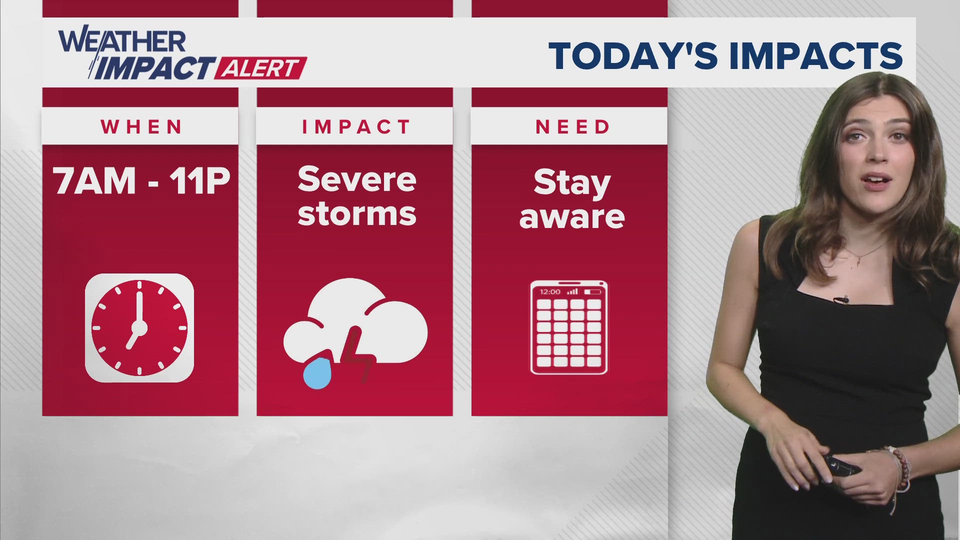
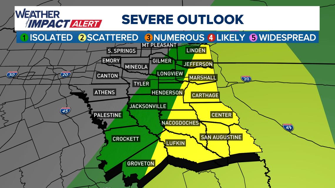
8:30 AM - The NWS says severe storms are expected throughout as the impacts from Beryl enter East Texas. Tornadoes will be possible, and given their association with a tropical cyclone, they will likely be quick spin-ups.
The expected start time of severe storms associated with Beryl's arrival in East Texas are as follows:
- Zone 1 (which includes Tyler, Longview, Rusk, Center, Lufkin and Hemphill) - 9-11 a.m.
- Zone 2 (which includes Mount Pleasant, Clarksville, Texarkana and Gilmer) - 10 a.m.-12 p.m.

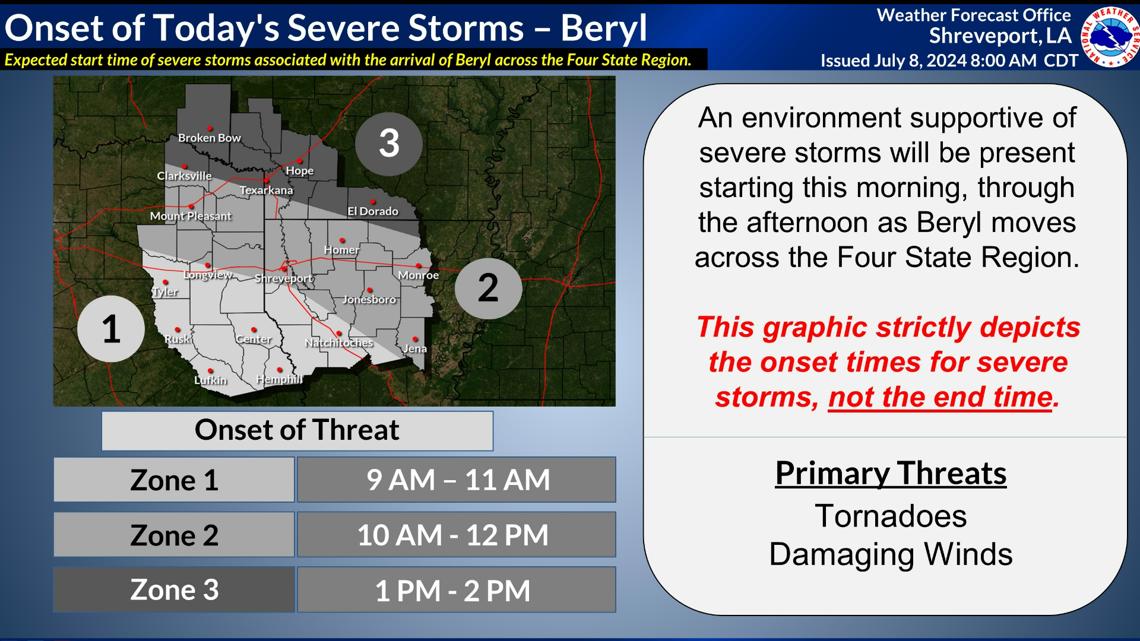
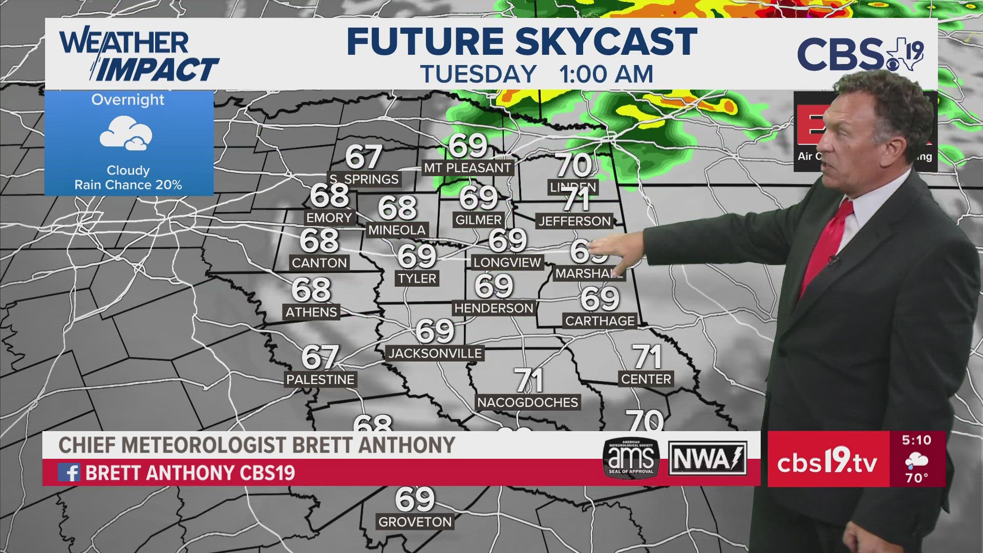
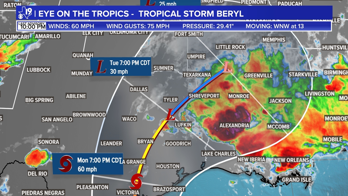
5:55 AM - The NWS says Beryl's center of circulation will enter Deep East Texas later today. The remnants will quickly move through East Texas and will exit the region altogether by Tuesday morning. The main impacts, given the current track, will include heavy rainfall, flash flooding and a few possible tornadoes.
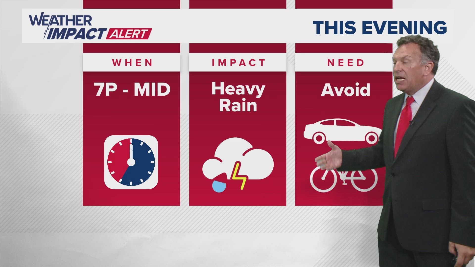
5 AM - CBS19 has issued a Weather Impact Alert Day for Monday as Beryl makes its way toward East Texas. When will the storm hit? What will the impact be? What do you need to do?
Check out the video below for more.
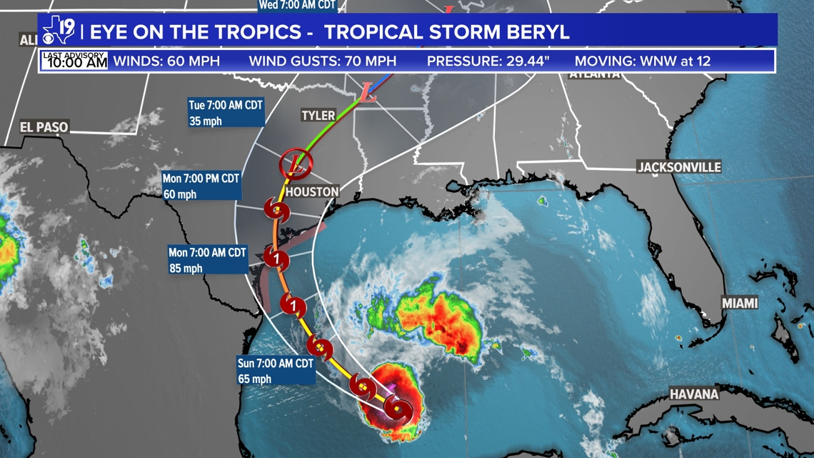
3:55 AM - Beryl has made landfall as a Category 1 hurricane near Matagorda.
▶Sunday, July 7
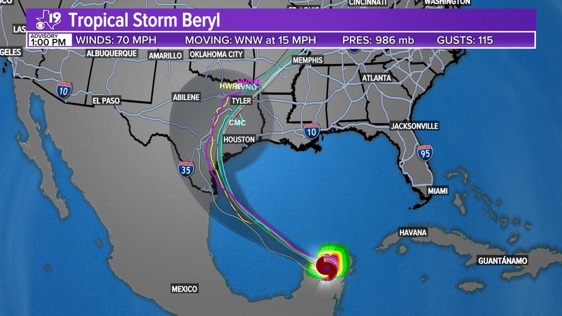
6 PM - As Beryl continues to strengthen, it should reach hurricane status before making landfall Monday morning. The current trajectory shows it closer to Port Lavaca before it moves north and weakens into a tropical storm. It will pick up speed and move quickly through East Texas.
Check out the timeline in the photos below:


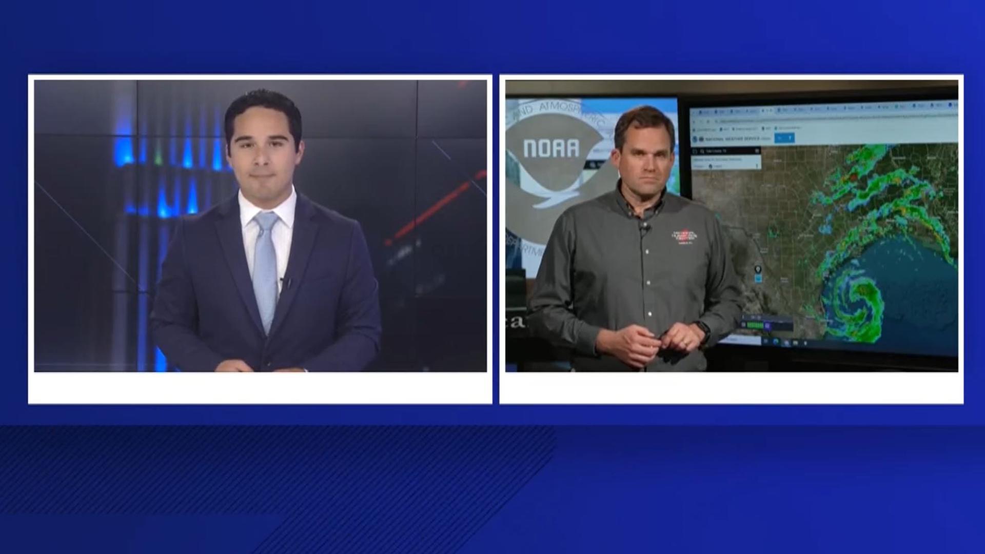
5 PM - CBS19 spoke with Dr. Michael Brennan, director of the National Hurricane Center, about Beryl and its potential impact on East Texas.
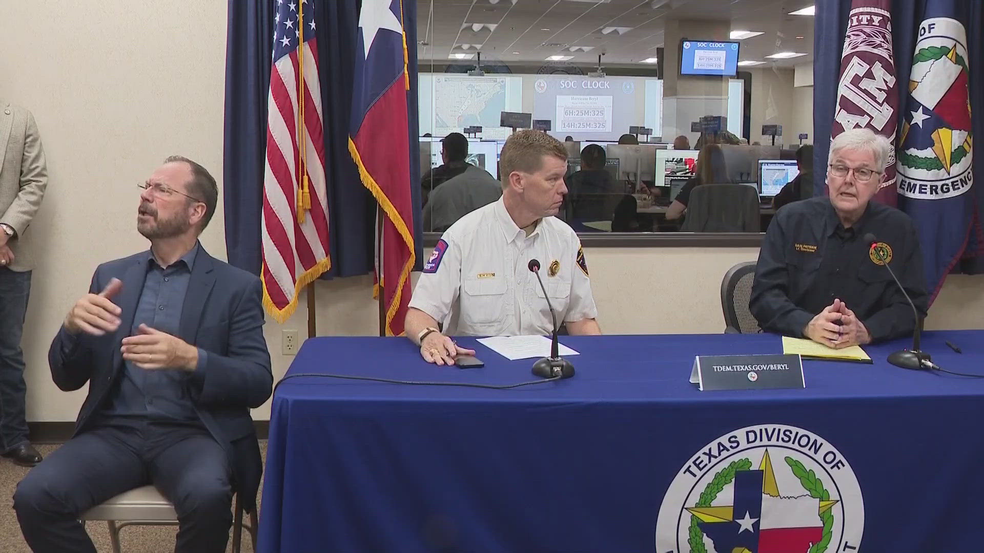
4:20 PM - Lt. Gov. Dan Patrick held a press conference Sunday afternoon on the state's preparedness ahead of Beryl making landfall on the Texas coast.
“As Hurricane Beryl approaches the Texas coast, now is the time for Texans to make their final preparations to protect themselves and their property," Lt. Gov. Patrick said. "One hundred twenty-one counties are already under state disaster declaration, and more may be added if conditions warrant. Beryl is expected to intensify right up to landfall and could transform into a Category 2 Hurricane. Landfall is expected early Monday morning between 1 a.m. and 3 a.m. between Corpus Christi and Galveston. Beryl is a resilient storm, and it poses a serious threat for Texans in its path at landfall and the following 24 hours as it moves through Texas. The storm’s predicted path is shifting east, and the areas east of the I-35 corridor are expected to bear the brunt of the inclement weather. Residents sheltering in place should take precautions right away for sustained wind, heavy rain, flooding, storm surges on the coast, and possible tornadoes. It is of utmost importance that Texans pay close attention to their local officials. As Acting Governor, I am in constant communication with state agencies and will continue to do so. Do not ignore this very serious storm.”
Watch the full press conference in the video below.
2:45 PM - The NWS has issued a Severe Thunderstorm Warning for Angelina, Cherokee and Nacogdoches counties until 3:30 p.m. Sunday.
1:55 PM - The NWS has issued a Flood Watch for the following counties until 4 p.m., Tuesday:
- Angelina
- Camp
- Cass
- Cherokee
- Franklin
- Gregg
- Harrison
- Morris
- Nacogdoches
- Panola
- Rusk
- Sabine
- San Augustine
- Shelby
- Smith
- Titus
- Upshur
10:37 AM - According to the CBS19 Weather Experts, East Texas' biggest threat will be heavy rainfall. There is also a tornado threat as the storm moves inland.


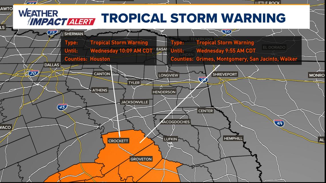
10:15 AM - The NWS has issued a Tropical Storm Warning has been issued for Trinity and Houston counties until further notice.

3:55 AM - The National Weather Service (NWS) has issued a Flood Watch for the following counties from Monday, July 8 at 7 a.m. - Tuesday, July 9 at 7 a.m.:
- Anderson
- Henderson
- Rains
- Van Zandt
The NWS says excessive runoff may result in the flooding of rivers, creeks, streams, and other low-lying and flood-prone locations. Rainfall totals of 4"-7", with isolated higher amounts up to 10", are possible.
▶Saturday, July 6
7 PM - FEMA is monitoring Hurricane Beryl, which is set to affect portions of Texas with dangerous storm surge and flash flooding. FEMA says they are coordinating closely with state, local and tribal partners. At this time, there are no unmet needs.
FEMA has provided the following tips to stay safe before, during and after a hurricane:
- Do not focus on the exact track of this storm. Tropical storm force winds may extend up to 125 miles from the center. Additionally, large swells generated by Beryl are expected to reach much of the Gulf Coast today. These swells are expected to cause life-threatening surf and rip current conditions.
- Be in the know about your evacuation zone. You may have to evacuate quickly due to a hurricane if you live in an evacuation zone. Act now by learning your evacuation routes, practice with your household and pets, and identify where you will stay. Learn more about how to evacuate safely on Ready.gov.
- Know how to stay safe during high winds, storm surge and flooding. Determine how best to protect yourself from high winds and flooding. Evacuate immediately if you are told to do so. Take refuge in a designated storm shelter or an interior room for high winds. Go to the highest level of the building if you are trapped by flooding. Do not climb into a closed attic. You may become trapped by rising flood water.
- Stay informed. It’s important for residents and visitors in these areas to follow the instructions of state and local officials by monitoring local radio or television stations for updated emergency information.
- Turn Around. Don’t Drown®. Driving through a flooded area can be extremely hazardous. Almost half of all flash flood deaths happen in vehicles. When in your car, look out for flooding in low lying areas at bridges and at highway dips. As little as 6 inches of water may cause you to lose control of your vehicle or fall if you are walking through it. Two feet of rushing water can carry away most vehicles including sport utility vehicles (SUVs) and pick-ups.
- Stay out of floodwater. Walking, swimming, or driving through flood waters is extremely dangerous. Standing water may be electrically charged from underground or downed power lines or contain hazards such as wild or stray animals, human and livestock waste, and chemicals that can lead to illness.
- Have a plan. Make sure you consider your family’s unique needs, including anyone who needs medicine or medical equipment. Know how you’ll contact one another and reconnect if you aren’t together when a severe storm hits. Visit Ready.gov or Listo.gov for more information on how to stay safe before, during and after severe weather.
3:25 PM - Acting Gov. Dan Patrick urged Texans to make final preparations and announced he has added 81 counties to the state’s Hurricane Beryl Disaster Declaration as storm forecasts have shifted the expected landfall north and east of previous projections. This brings the total number of Texas counties included in the state’s disaster declaration to 121.
Upon updating the disaster declaration, Acting Governor Patrick issued the following statement:
“As Hurricane Beryl approaches the Gulf Coast, today and tomorrow will be the last 2 days for Texans to make preparations for the coming storm. Beryl is a determined storm, and incoming winds and potential flooding will pose a serious threat to Texans who are in Beryl’s path at landfall and as it makes its way across the state for the following 24 hours. Based on the current forecast, heavy rain and some localized flooding could occur all the way from the coast through areas near College Station, Tyler, and Texarkana as the storm moves through Texas on its current track. The track may change over the next 40 hours. Texans need to take heed, watch their local officials, and prepare today and tomorrow before the storm makes landfall early Monday morning. As Acting Governor, I’ve been in constant communication with Texas state agencies and local leaders to coordinate preparations and response, and I will continue to do so. Do not ignore this storm.”
The East Texas counties included in the disaster declaration are:
- Anderson
- Angelina
- Camp
- Cass
- Cherokee
- Franklin
- Gregg
- Harrison
- Henderson
- Hopkins
- Houston
- Marion
- Morris
- Nacogdoches
- Panola
- Polk
- Rains
- Rusk
- Sabine
- San Augustine
- Shelby
- Smith
- Titus
- Trinity
- Upshur
- Van Zandt
- Wood
According to the National Hurricane Center, Tropical Storm Beryl is expected to intensify as it moves northwest through the Gulf of Mexico, before it takes a northerly turn to make landfall along the mid-Texas coast as a hurricane on Monday. Interests in Texas should closely monitor this system and finalize preparations for hurricane impacts, including heavy rainfall, flooding, potential tornadoes, and damaging winds as the system moves inland across the state.
The Texas Division of Emergency Management (TDEM) increased the readiness level of the State Emergency Operations Center as of 10 a.m. Friday and Texas Emergency Management Council agencies are working 24-hour operations, while also continuing to preposition state emergency response resources that were readied for deployment by Governor Greg Abbott on Thursday.
The State of Texas currently has more than 2,000 responders and 850 assets rostered and deployed in support of the state’s response to anticipated impacts from Hurricane Beryl. The following state emergency response resources have been rostered and deployed to support response operations:
- Texas A&M Engineering Extension Service (Texas A&M Task Force 1 & Texas Task Force 2): Search and Rescue Personnel, and Swiftwater Boat Squads.
- Texas A&M Engineering Extension Service: Texas A&M Public Works Response Team.
- Texas A&M Forest Service: Texas Intrastate Fire Mutual Aid System (TIFMAS) All-Hazards Incident Strike Teams, including personnel and fire engines.
- Texas National Guard: National Guard Personnel, including High Profile Vehicles and Chinook & Black Hawk Helicopters.
- Texas Department of Public Safety: Texas Highway Patrol Troopers, the Tactical Marine Unit, and Helicopters with hoist capabilities.
- Texas Parks and Wildlife Department: Game Wardens and Park Police to provide law enforcement support, along with Swiftwater Boats, Airboats, Flat Bottom Boats, Four-wheel Drive Vehicles, and Helicopters.
- Texas Department of State Health Services (Emergency Medical Task Force): Medical Incident Support Teams and Severe Weather Packages, including Ambuses, Ambulances, and Command Vehicles.
- Texas Department of Transportation: Highway maintenance personnel and personnel to monitor roadway conditions.
- Texas Animal Health Commission: Personnel to provide livestock support.
- Texas A&M AgriLife Extension Service: Disaster Assessment and Recovery Agents as well as AgriLife Extension Agents to support agricultural and livestock needs.
- Texas Department of Information Resources: Monitoring for potential cyber-threats and impacts to technology infrastructure.
- Texas Commission on Environmental Quality: Air/water/wastewater monitoring
- Railroad Commission of Texas: Monitoring the state’s natural gas supply, and communicating with the oil & gas industry.
- Public Utility Commission of Texas: Personnel to coordinate with utility providers across the threat area.
- Texas Voluntary Organizations Active in Disaster: Coordinating volunteer organizations across impacted areas.
- FEMA Region 6: More than 100 personnel, 500,000 Meals Ready to Eat, 800,000 liters of Water, 20,000 Tarps, 2,500 Rolls of Plastic Sheathing, Generators, Urban Search and Rescue Teams, Tractor-Trailers, Communications and Command Vehicles.
11:45 AM - Beryl remains a tropical storm with sustained winds of 60 mph over the open waters of the Gulf of Mexico. The storm is encountering some relatively dry air and strong winds higher in the atmosphere that should prevent it from becoming a hurricane until just before landfall Sunday night or Monday morning.

▶Friday, July 5
10:30 PM - The National Hurricane Center has updated the path of the storm. Beryl could be considered a tropical storm by the time it reaches East Texas.

8:30 PM - Expect lots of rain on Monday as Beryl makes its way into East Texas. Forecast models suggest between 2 and 7 inches of rain will be possible over parts of East Texas.