TYLER, Texas — Every year, about this time, a new, unique weather pattern begins to unfold right before our eyes. Over the coming weeks, we will watch this weather pattern become established.
This weather pattern will begin to cycle. We typically have a rough idea of the cycle length by the start of meteorological winter. This can help us accurately predict Arctic air outbreaks, winter storms and even severe weather set ups.
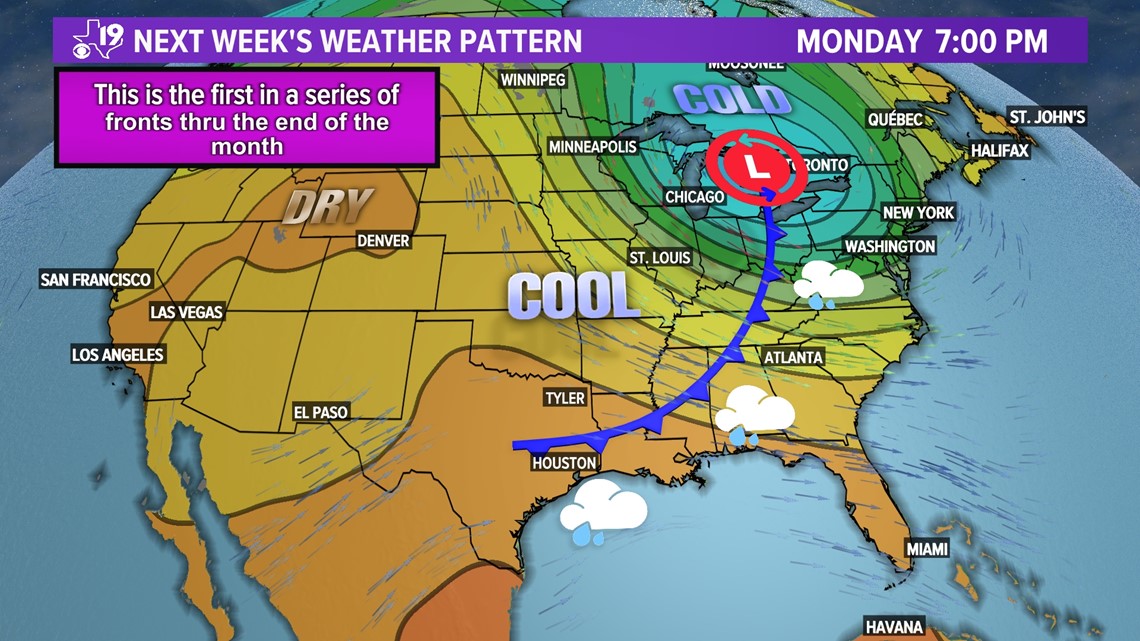
Next week, it appears that the first signature storm of the new weather pattern will develop with a deep low over the Great Lakes and a high amplitude ridge over the western United States.

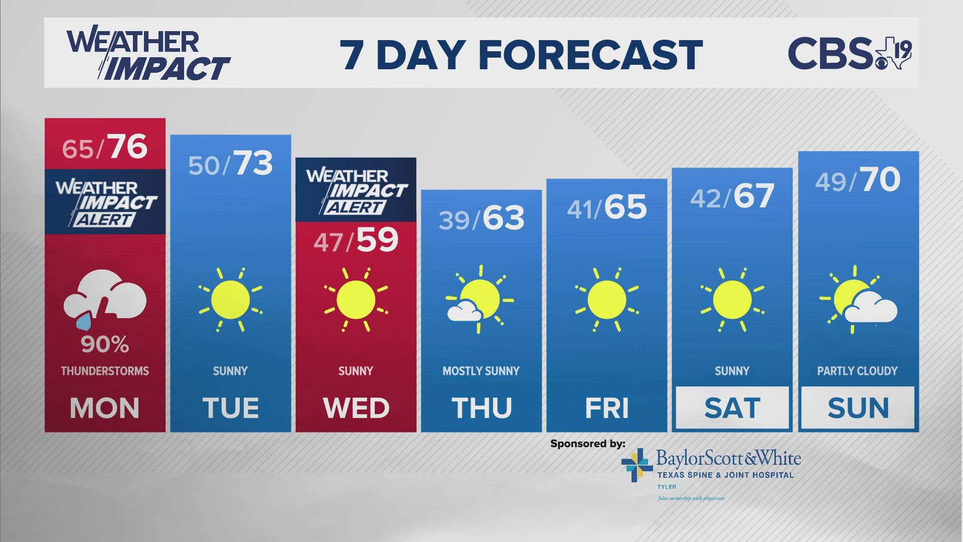
This weather pattern means a seasonably strong cold front will move through East Texas over the weekend and we will get a nice dose of autumn air around Oct. 17. Overnight lows will dip into the 40s and parts of the piney woods will see highs only the 60s, even with sunshine. This cold front is just the start of a parade of fronts that will march through East Texas between Sunday and the end of the month.

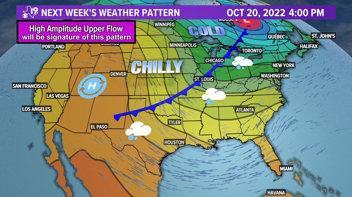
This weather pattern will push a second front through the area late next week. This front will reinforce the cool air already in place.
Why is this important?
Because this weather pattern will repeat this winter and next spring. We don't know exactly when yet, but as the weather pattern becomes established we will be able to pick out key dates when cold air will arrive in East Texas and bring in either rain, snow or ice.
The Long Range Cycling theory examines the upper level winds and uses an index that predicts when similar features in the upper level flow will return to a region. Sometimes the cycling weather pattern can be influenced by global weather oscillations, such as El Nino and La Nina.
We know for the third straight winter that La Nina conditions will be present in the eastern Pacific. When cooler waters are present in the eastern Pacific, it can cause the jet stream or winds about 25,000 feet off the surface to bulge over the western United States and buckle over the eastern U.S.

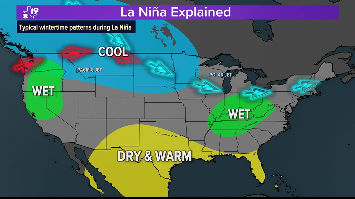
Typically, this causes cool, rainy weather to persist across the northern plains and creates wetter than average weather for the Great Lakes and Ohio River Valley. When both the pacific and polar jet streams are flowing over the northern plains, the southern plains and most of Texas ends up warm and dry.
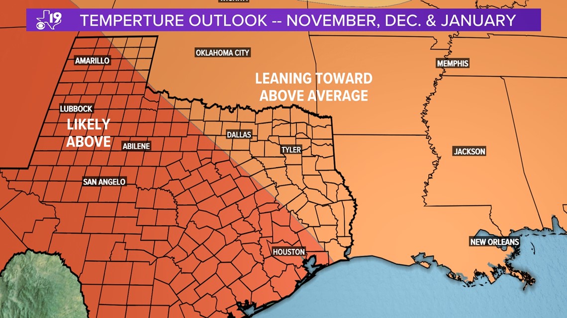
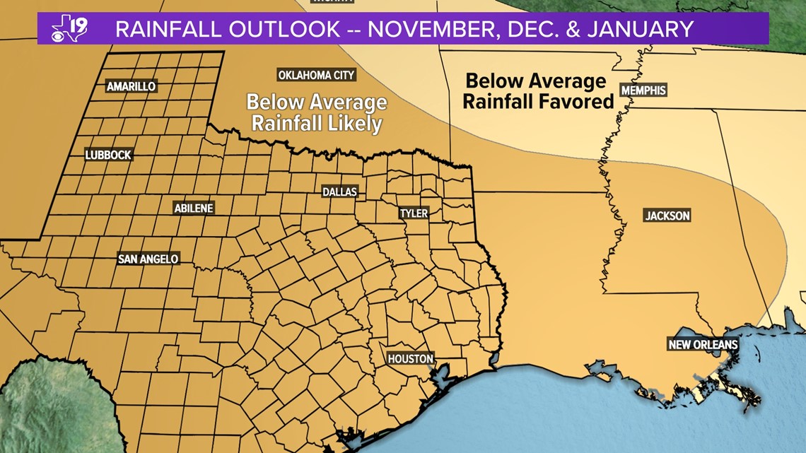
Later this month, the Climate Prediction Center will issue an updated three month outlook for November, December and January. Outlooks issued in mid-September somewhat mirrored what climatology tells us about the transition from fall to a La Nina winter.


But what's really happened during La Nina winters?
We can drill down a little further and examine the data from the National Oceanic Atmospheric Administration Regional Climate Center. The data for some recent La Nina episodes reveal that winter in East Texas doesn't always go according to plan when it comes to La Nina.
Remember February 2021?

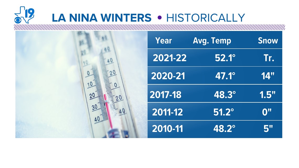
A safe conclusion from the above data is that La Nina winters appear quite variable. This winter is a rare triple dip La Nina. So far we've had one cold, snowy winter and one relatively mild, snow-free winter. The closest and most recent comparison are the winters of 2010-11 and the winter of 2011-12.
So what will happen?
Go back to the beginning of this article. Remember how I showed a parade of cold fronts between now and the end of October?
This pattern will repeat this winter. That means get ready for some cold air outbreaks, maybe some snow or ice, but it won't last long; overall our winter will probably end up warmer than average.
If you've got any questions about the Long Range Cycle Weather pattern, or any other questions, just drop us an email at weather@cbs19.tv.