TYLER, Texas — CBS19 wants to make sure you're prepared for the severe weather threat looming over the area Monday. That's why we've put together a live blog we will continuously update throughout the day with the latest information provided by the CBS19 Weather Team and the National Weather Service.
Monday's severe weather event may come in two waves. The first severe thunderstorm or tornado warning may be issued late morning for extreme East Texas
Later in the afternoon, an area of even stronger wind shear will move in. Add in more warmth and moisture and the High-Resolution Rapid Refresh depicts the possibility of numerous supercells developing in East Texas.
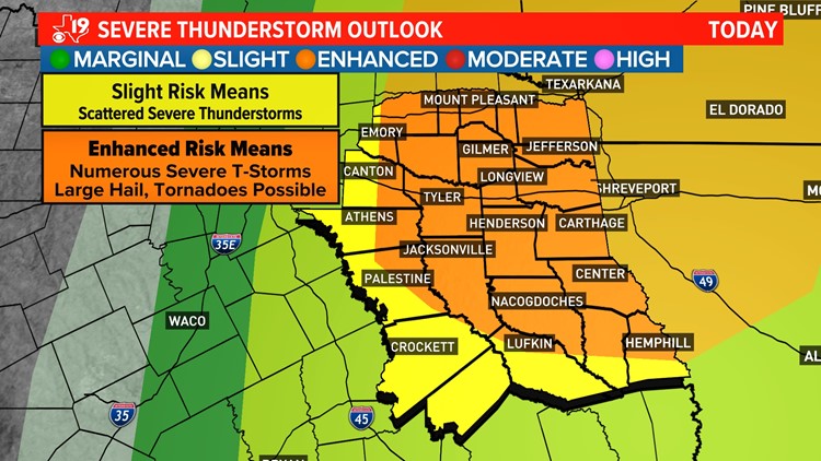
Most of East Texas is under an Enhanced Risk for severe weather.
FOLLOW HERE FOR LIVE UPDATES:
9 PM: FLASH FLOOD WARNING until 12:15 a.m. Tuesday for Harrison, Shelby and Panola counties.
9 PM: TORNADO WATCH until 3 a.m. Tuesday for Sabine, Shelby, San Augustine and Panola counties.
5 PM: FLASH FLOOD WARNING until 8 p.m. for Sabine, Nacogdoches, Shelby, Angelina and San Augustine counties.
3:46 PM: FLOOD ADVISORY until 6:45 p.m. for Sabine, Shelby, Angelina and San Augustine counties.
2:37PM - TORNADO WARNING issued for Sabine and Shelby counties until 4 p.m. TORNADO WARNING issued for San Augustine County until 3:30 p.m.
2:27PM - More than 4,000 East Texans are without power.
2:08PM - SEVERE THUNDERSTORM WARNING issued for the following counties until 3 p.m.:
- Angelina
- Sabine
- San Augustine
2PM - TORNADO WARNING Issued for Jasper County.
1:19PM - TORNADO WATCH issued for the following counties until 9 p.m.:
- Angelina
- Camp
- Cass
- Cherokee
- Franklin
- Gregg
- Harrison
- Marion
- Morris
- Nacogdoches
- Panola
- Rusk
- San Augustine
- Shelby
- Smith
- Titus
- Upshur
- Wood
1:11PM - Chief Meteorologist Brett Anthony expects a TORNADO WATCH to be issued soon.
9:52AM - Once we hit 11a.m., we'll begin to see stronger thunderstorms develop in Deep East Texas. Through the early afternoon, these will lift across the region, with damaging wind gusts and hail as the main threats. A brief tornado is possible with these, as well. Later this afternoon, another round of strong thunderstorms will fire up and move through East Texas. These will be stronger than the initial batch and will feature all of types of severe weather, including a few tornadoes. This second wave of strong storms will last until about 9 p.m.
7:52AM - Severe weather is expected to increase into the afternoon hours, and remain into the overnight hours as well. All modes of severe weather will be possible over the next 24 hours, including tornadoes. The tornado threat will come in both the traditional Supercell form, and eventually the Quasi-Linear Convective System (QLCS) form. Given the strongly sheared environment, a few of these tornadoes could be strong. Heavy rain and isolated flash flooding may also become a concern, but that is more likely in the portions of our area under a Flood Watch.
Stick with CBS19 on air or the free CBS19+ 24/7 live-streaming app for the latest updates from our weather team.


